The TransAmerica Trail, or TAT, is an off-road route that spans 13 states and cuts across deserts, mountains, and rivers, stretching coast to coast. Historically unmarked and difficult to locate without insider knowledge, it has long been a playground for overlanding enthusiasts and motorcyclists seeking remote terrain and minimal human interference. By making the trail available on Google Maps and Street View, the project offers broader public access to one of America’s wildest cross-country routes.
This effort also underscores the growing intersection between automotive tech and digital mapping. It’s a move that fits squarely within Ford’s larger “Ready Set Ford” initiative, aimed at promoting outdoor exploration using its off-road-ready vehicles. For Google, it represents an expansion of its mapping footprint beyond urban streets and into unmarked wilderness trails—territory that has, until now, remained largely absent from the platform.
Documenting a Hidden Route From Coast to Coast
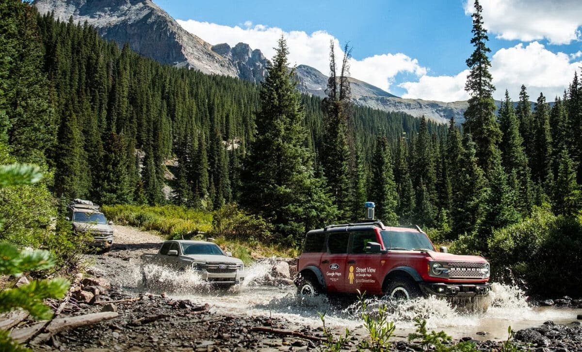
To complete the mission, Google mounted its Street View camera onto a Ford Bronco Badlands, with a Ford Ranger Lariat and Ford Expedition Tremor forming the support convoy. According to Popular Mechanics, the Bronco was the only vehicle to receive a significant modification—its camera. The rest of the gear, people, and logistics were managed by the trailing vehicles.
The Ranger, Ford’s mid-size pickup, was responsible for carrying most of the load and could tow up to 7,500 pounds in case of emergencies or trail blockages. The Expedition, with its split rear gate, doubled as a workspace and a mobile kitchen for the crew.
The convoy tackled various trail conditions, from deep desert sand to muddy Eastern crossings and narrow, high-altitude passes in the Rockies. Alexis Beck, Ford’s marketing manager who joined the trip, highlighted the significance of the route, pointing out that Imogene Pass in Colorado stood out as the most extreme terrain: “It was almost like being on a roller coaster,” she said. The team camped overnight and sent image data back each evening, documenting the trail in near real-time.
Unpredictable Conditions Shaped the Daily Route
Despite extensive preparation, the crew adapted their route on a day-by-day basis. Weather had a major impact on their decisions. One example involved a segment in Virginia, where rain forced the team to pause and reroute due to washed-out paths. According to Beck, the flexibility of the vehicles and the team’s ability to adjust quickly was essential for completing the expedition safely.
The conditions they encountered demonstrate why the TAT has never been properly mapped before. Unlike traditional roads, these trails can change rapidly with the weather and have no signage. The decision to capture the trail now means that for the first time, future trail users can preview segments visually and plan with significantly more information than before.
No Follow-Up Planned—Yet Anyone Can Contribute
Although the TAT expedition was a major undertaking, Ford does not currently plan to continue mapping other off-road trails. However, Google’s platform does allow individuals to contribute Street View content. With a Google-certified 360 camera, anyone—on foot, bike, or vehicle—can upload imagery to the platform. This means that while Ford’s involvement may pause here, the expansion of trail data is now technically open to anyone with the right tools.
The route mapped by the team is already visible on Google Maps, providing visual references in previously uncharted sections near locations like Lake City, Colorado. These additions could significantly alter how off-roaders prepare for future adventures. For now, the 32-day trek remains a unique example of how automotive tech and digital cartography can intersect to open up even the most remote corners of the United States.